MAIN RESTORATION WORKS A STEP CLOSER.
Three successful applicants have been shortlisted from the first phase of the procurement process for the main restoration works for K2A.
Read more by going to COMMUNITY INFORMATION - PROJECT UPDATES or PROJECT CONSTRUCTION
WORKS ONGOING IN 2026
Blackbird Flat - pavement sealing / Flying Fox Cutting - pavement sealing / Big Hill - three curves constructed as unsealed pavement
Kempsey-Armidale Road Restoration Project (K2A)
The Kempsey-Armidale Road is an important corridor, which links Armidale and the coast. The road also supports the local community and agriculture and tourism industries in both the Armidale and Kempsey regions.
The road was severely damaged by bushfires at the end of 2019 and subsequent flooding in 2020 and 2022:
- Bushfire, NSW bushfires: 31 August 2019 onwards
- Storm and Flood, NSW storms and floods: 15 January 2020 onwards
- Heavy rainfall in February and March 2022
The condition of the road has deteriorated due to these natural disasters and several landslips have occurred. Emergency recovery works have been undertaken at several locations where the severe damage to the road occurred from these natural disasters. Council is now working to prepare the tender for the main recovery works.
Council is working to rehabilitate and restore 46 kms of Kempsey-Armidale Road and a 5 km section of Lower Creek Road to pre-disaster condition.
The Natural Disaster Recovery Works is jointly funded by the Commonwealth and NSW State Government.
This will fund activities that restore the road to its pre-disaster condition.
Kempsey-Armidale Road Restoration Project scope of works:
- Main Works - Restoration of approximately 46km of Kempsey-Armidale Road and approximately 5 km of Lower Creek Road to pre-disaster condition. The works are jointly funded by the Commonwealth and NSW State Government.
Kempsey-Armidale Road Improvement Projects are comprised of the following three projects which are being delivered under 'Fixing Local Roads' (FLR) and 'Fixing Country Roads' (FCR) funding grants provided by the NSW State Government.
- Blackbird Flat - FLR, Blackbird Flat Cutting and includes some pavement sealing (ongoing)
- Flying Fox Cutting - FLR, Flying Fox Cutting and includes some pavement sealing (ongoing) and
- Big Hill - FCR, three curves on Big Hill being constructed as unsealed pavements (ongoing).
Fixing Country Roads (FCR) is a key NSW Government program providing targeted infrastructure funding from Restart NSW for projects that unlock economic potential of Regional NSW.
Fixing Local Roads (FLR) funding is provided by the NSW Government to enable councils to accelerate upgrades and maintenance on their local road network.
Road Status
Road restrictions
Based on independent getechnical advice, Council has found it necessary to impose several restrictions in relation to use of the road.
Kempsey-Armidale Road is closed to the general public until further notice due to landslides and unstable road pavements resulting from a series of extreme weather events since 2019.
The road is open to local residents for essential travel and for emergency and essential services only.
A number of other measures have also been put in place. They are as follows:
Load limits
The road is currently rated for vehicle weights/loads up to 10 tonne gross vehicle mass (gvm).
Increased load limits have been put into place to assist local residents with day to day needs such as essential deliveries, machinery movements and access to cattle sale yards, where loads exceed 10 tonne gvm and are less than 20 tonne gvm.
These increased loads can be taken advantage of on Wednesdays, Thursdays and Fridays each week subject to a safety inspection of the road prior to the day of intended travel. Those wanting to make use of this opportunity must register online 48 hours prior to each day they wish to travel. They must also fill in an online induction form (once only) prior to their first registration.
These forms can be accessed on the FORMS page on this website.
Length limits
Due to the condition of the road and the numerous tight corners, vehicles in excess of 12.5m are not permitted to travel within the project boundaries.
Use of UHF radios
All authorised users of the road are advised to use UHF radios and to call up other vehicles using call sign channel 17. This is especially important when increased load limits are happening.
Residents can find more information on the COMMUNITY INFORMATION page on this website
George's Junction Campground
George's Junction Campground is closed and barriers have been placed to prevent access to the site.
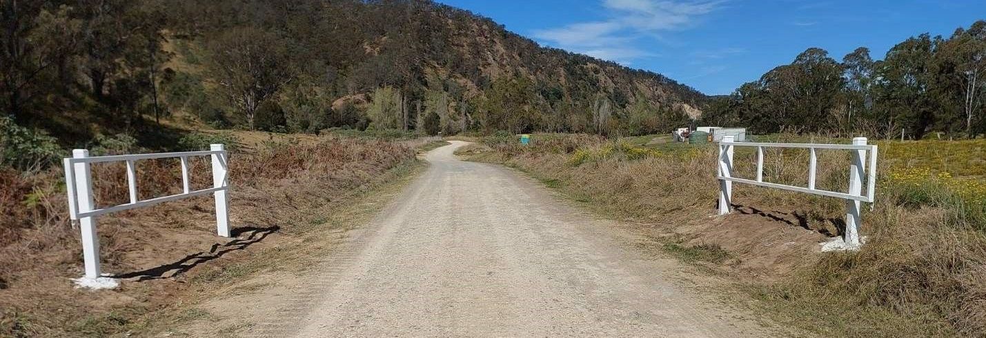
Gates for emergency road closures
Gates have been installed at either end of the project at Blackbird Flat and Big Hill near Styx River Forest Way in the event the road needs to be closed due to any emergency, natural or otherwise.